Scafell Pike & Great End 26th June 2010
|
|
|
Scafell(GPX) (right click>save as) |
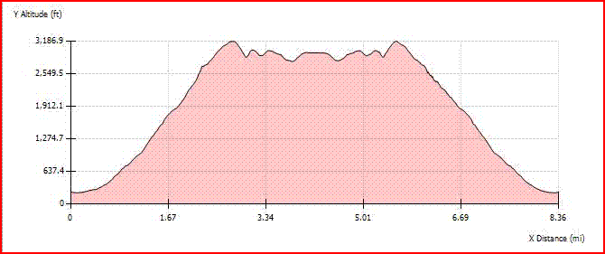
| TOTAL DISTANCE | 8.36 MILES | START CO-ORDINATES | 54.457°N, 3.265°W | |
| TOTAL DTM DISTANCE | 8.6 MILES | TOTAL ASCENT | 4,241.7ft | |
| AVERAGE SPEED | 1.61 MPH | TOTAL DESCENT | 4,238.8ft | |
| TRIP START TIME | 26/06/10 06:34 | MIN ALTITUDE | 219.9ft | |
| TRIP TIME | 5 HRS 12 MINS | MAX ALTITUDE | 3,186.9ft | |
| TOTAL ASCENT DISTANCE | 3.4 MILES | % OF ASCENT | 39.5% | |
| TOTAL DESCENT DISTANCE | 3.4 MILES | % OF DESCENT | 39.6% | |
| TOTAL LEVEL DISTANCE | 1.8 MILES | % OF LEVEL | 20.9% |

I heard on the radio as I was driving up that people were wishing their nearest and dearest good luck in the 3 peak challenge today. I get there just pass half six and you'd think it was gone ten. Well despite the beeb saying oh what a clear sunny day it was going to be, it was totally overcast. Which I was glad at. The walk starts gently and gained height without much trouble. Though it gets less and less gentle as the route progresses.
After about 2/3 of the way to Scafell Pike the path divided left or right. I took the right path, as it turns out the better route. The left path was teeming was walkers, whereas I shared the right path with no other.
The NT have been doing a lot of work repairing the pathways and in this instance a fine job they are doing. The only dodgy bit to Scafell Pike was the mad scramble up to Mickledore. Thought I was going to have to get my hard hat & ropes out. From Mickledore to the summit at the Pike was a gentler ascent, but mainly over boulders. Fortunately the cairn way was there to guide the traveler in the right path.
On getting to the summit, I was disappointed yet again by the cloud. The beeb showed that all morning it would be clear skies and again they are wrong. (As I write this the sun is just breaking through - 1245). The trig point had been wonderfully covered with the St George's Cross, made me think of the world cup match to be played tomorrow ENG v GER.
The terrain was the majority of the way rocky, though over Broad Crag was some else. It was composed of large jagged rocks/boulders, that have certainly not yielded to the trampings of man (and woman) over the years. It is rather precarious going. One false move and your leg would be down between the rocks, so a gentler pace is appointed by those that like life, on two legs.
From Broad Crag the cloud lifted enough to see Bow Fell and Crinkle Crags in the distance. The views were impressive by just the granduar of the altitude alone. The route to Great End was not so memorable as the terrain and the cloud stop the eye wandering from the path. Again at Great End I was hoping for great views, with the location of this peak they promise to be fine. Alas it was thwarted by cloud still. It was time for a quick reat then it was a simple re-trace of my steps back to my starting point near Wasdale Camping site.
It ain't Wainwright, but it's what I like.