Skiddaw
7th May 2010
| Skiddaw(GPX) (right click>save as) |
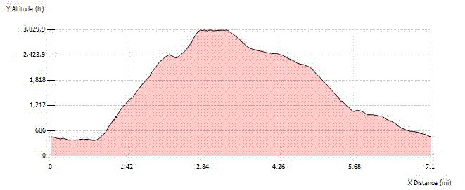
| TOTAL DISTANCE | 7.1 MILES | START CO-ORDINATES | 54.62°N, 3.136°W | |
| TOTAL DTM DISTANCE | 7.25 MILES | TOTAL ASCENT | 3049 ft | |
| AVERAGE SPEED | 1.99 MPH | TOTAL DESCENT | 3049 ft | |
| TRIP START TIME | 07/05/10 07:02 | mIN ALTITUDE | 379.5 ft | |
| TRIP TIME | 3 HRS 34 MINS | MAX ALTITUDE | 3029.9 ft | |
| TOTAL ASCENT DISTANCE | 2.49 MILES | % OF ASCENT | 34.3% | |
| TOTAL DESCENT DISTANCE | 4.04 MILES | % OF DESCENT | 55.7% | |
| TOTAL LEVEL DISTANCE | 0.72 MILES | % OF LEVEL | 9.9% |

It seems the better walkin weather is in the winter months, no matter what I get clear skies. As soon as Spring arrives it is cloud cloud cloud. I managed a good early start which helped me miss the rush hour traffic and arrived at Applethwaite just before 7am.
The walk started with a a pleasant walk down the road to Millbeck, the varied of plants was something I noticed straight away. From trees to bushes to wild flowers.
50yds over Mill beck the path to Skiddaw began. The ascent up Doups had some great views behind. The above picture shows the what would of promised to be great views further up. Except for that just under 2000ft the cloud decided to envelope the entire environment. You can just make out Scarfell just above Catbells.
Once in the cloud it was trying to dampen me, first with a little drizzle then with hail. Both were very short lived, though the wind did pick up. I noticed the wind change, but with the uphill climb I never noticed the change in temperature. Which was significant.
The big downside of the way I went and of course the Cloud, was you at no point in the walk saw the summit or any clue to where it was other than the map. Reaching Carl Side I turned down the option to take the detour to Ullock Pike, which I regret not doing now, as time was on my side. I had my mind on the wind which was still picking up.
From Carlside Tarn it was just over 1/2 mile to Skiddaw summit. That last bit to the summit the terrain changed to scree. Then suddenly out of nowhere a stone shelter appeared out of the mist. With the cold wind whipping over the summit, ice was forming on the stones and on the grass. Unfortunately I felt it with too late to put my jump on, so I kept moving to keep warm.
I was really hoping to get a panoramic picture from the summit of the surrounding fells and mountains. Well if it was more than 10meters away from me then there was no way of me photographing it.
I hurried down the other side as quick as to trying keep warm and get back to warmer environment. I'd reached the summit by 0900 and I was over half way down before I passed anyone the other way. On the way down I was treated to a quick glimpse of an Osprey on its hunt. Then further down towards the cap park at the end of the road, skylarks whistled in with their tune.
From the car park to where I was parked by the fork in the road by the hotel was a fine walk in itself. I look forward to going back on a les cloud covered day.